Ulleungdo, a volcanic island far off the eastern side of the Korean peninsula, boasts an awe-inspiring natural landscape unlike anywhere else in the country. Arresting rock formations, lush forests, and clear emerald waters make Ulleungdo a must-see destination. Designated a National Geopark in 2012, the island’s stunning scenery belies a tumultuous history.
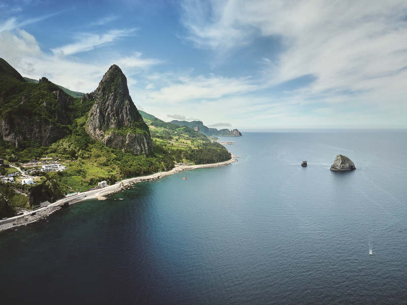
Songgotsan, standing 450 meters high, sits at the northernmost tip of the Seonginbong mountain range in central Ulleungdo. Located close to the coast, this popular destination for experienced mountaineers is even more imposing when seen from the water.
Located in the deep waters of the East Sea, Ulleungdo is the product of volcanic eruptions during the current Cenozoic Era, which began 66 million years ago. Situated at the easternmost point of Korean territory, some 140 kilometers off the coast, it is surrounded by scores of islands big and small, the most famous among them being Dokdo, Jukdo, and Gwaneumdo.
Covering 73 square kilometers, Ulleungdo is the summit of a stratovolcano formed by undersea eruptions, resulting in breathtaking landscapes of steep slopes and unusually shaped bluffs. Whichever roads and trails visitors take, they are met with stunning views at every turn. This natural beauty makes tourism the cornerstone of the island’s economy.
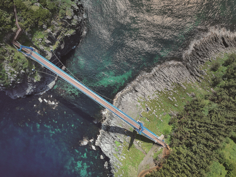
Gwaneumdo is known as a paradise for wild plant life, with forests preserved in their primeval state. A suspension bridge built in 2012 makes it the only neighboring island accessible from Ulleungdo by foot.
SCULPTED BY NATURE
To get to Ulleungdo, travelers need to take a passenger ship from Pohang, Mukho, Hupo, or Gangneung. Ships departing from Pohang and Hupo dock at Sadong — a port once known as “Jangjakjipo,” meaning “an inlet with a long stretch of pebble beach.”
Many place names on Ulleungdo are evocative of natural features. For example, Wadal-ri, a village located at the foot of a cliff in the eastern part of the island, was named after “wadal,” the sound of rocks rolling down the steep slopes. A coastal road encircles the island; the section from Guam Village in Seo-myeon to Hakpo Port traverses a serpentine overpass, built to follow the sloping terrain, that used to be called Mulchingching, meaning “water flowing down in tiers.” In the past, Hyeonpo Village in Buk-myeon was called “Heukjakji,” which means “black pebble beach.”
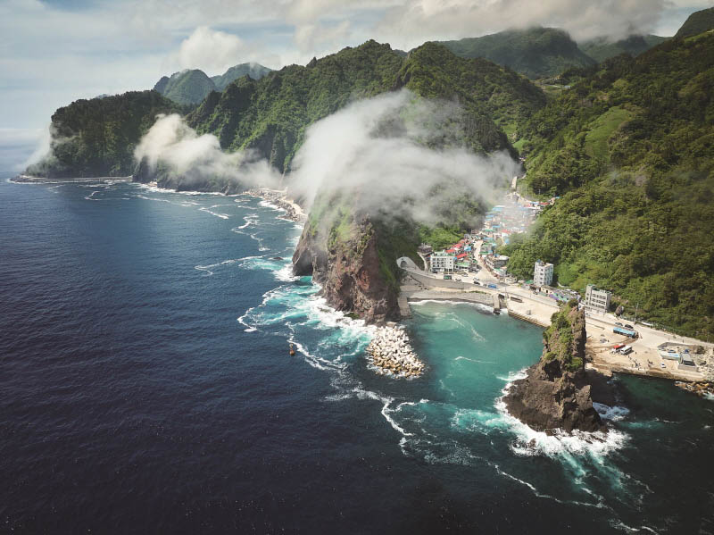
Buk-myeon is where the island’s most outstanding coastal landscape is found. The stretch from Hyeonpo Port to Seommok in particular features some of Ulleungdo’s most spectacular sights. These include Noinbong, a rocky summit that looks like thousands of stacked stone slabs; Songgotbong, a towering, awl-shaped peak that seems poised to pierce the sky; Gongam, a rock formation shaped like an elephant with its trunk dipped into the sea; Samseonam, three pillar-shaped rocks in the middle of the ocean associated with a legend of three celestial maidens; and Gwaneumdo, a nearby uninhabited island with twin sea caves.
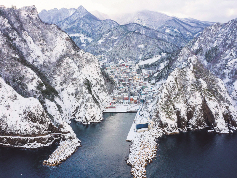
Dodong Port is the main gateway to Ulleungdo, where travelers departing from Pohang and Mukho arrive. It’s the busiest place on the island, where its major government offices and schools are located.
© Korea Tourism Organization
The clear, emerald waters surrounding Ulleungdo are also unmatched in their beauty. The hill near Cheonbu Port, famous for its magical sunsets, offers a sweeping view of Songgotbong and Gongam set gainst the glistening ocean.
On a clear day, from the top of the mountain pass at the northwestern tip of the island, the Taebaek Mountains — stretching along the eastern edge of the Korean peninsula — seem to loom close, as if within reach. Ulleungdo affords views of the mainland only about ten days a year, mostly in winter or at sunset, immediately after a storm has passed.
In the center of the island stands its tallest mountain, Seonginbong, at 986.5 meters. Just below is Nari Basin, the only substantial area of flat land, known for its traditional thatched houses and arable soil where mountain vegetables are grown.
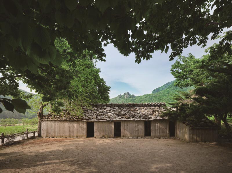
Nari Basin is the only substantial area of flatland on Ulleungdo, featuring traditional houses that offer a glimpse into the lives of islanders in years past. Pictured here is a 1940s house with a roof made of thin wooden shingles.
ANCIENT VESTIGES
The island is part of Ulleung County in North Gyeongsang Province, and is divided into three administrative districts — Ulleung-eup, Seo-myeon, and Buk-myeon. Its current population is slightly over 9,000. Until the 1970s, there were around 30,000 residents, but this number dropped to about 10,000 in the 2000s, then continued to fall until 2021, when it gradually began to rise again. Recent repopulation is attributed to former residents returning from the mainland and newcomers drawn by the island’s beauty.
Tonggumi Village in southern Ulleungdo is nestled in a deep, narrow ravine. The cliff to the west is a natural juniper tree habitat where original species still grow, making it an academically important site.
It is not clear when Ulleungdo began to be inhabited. Japan conducted the first archeological survey on the island during the 1910–1945 colonial period. After Korea’s liberation in 1945, the National Museum of Korea conducted excavations in 1957 and 1963, but many of the burial sites discovered had already been looted and destroyed. In total, 87 ancient tombs were found, most dating to the Unified Silla period (676–935). Built on mountain slopes, these stone-mound structures featured an entrance at the front. Stones were piled on top of the stone chamber, where the deceased was laid, without being covered in soil. Unique to Ulleungdo, this type of tomb made the best use of the island’s terrain and available materials.
More than thirty years later, archeologists returned. Between 1997 and 1998, the Seoul National University Museum conducted detailed surface surveys of tomb sites and relics scattered across the island. Three sites presumed to be dolmens were discovered, as well as earthenware fragments and polished stone tools, offering new insights into Ulleungdo’s history.
The first written record of the island appears in the History of the Three Kingdoms (Samguk sagi), published in the 12th century. It mentions that in the early 6th century, the Silla Kingdom (57 BCE–935 CE) conquered the State of Usan, which occupied Ulleungdo, and that Usan agreed to send products to Silla as annual tribute. From these records it can be surmised that Usan was integrated into Silla’s cultural sphere, and the academic community generally agreed that Ulleungdo’s history began in the 6th century when Usan was subjugated by Silla.
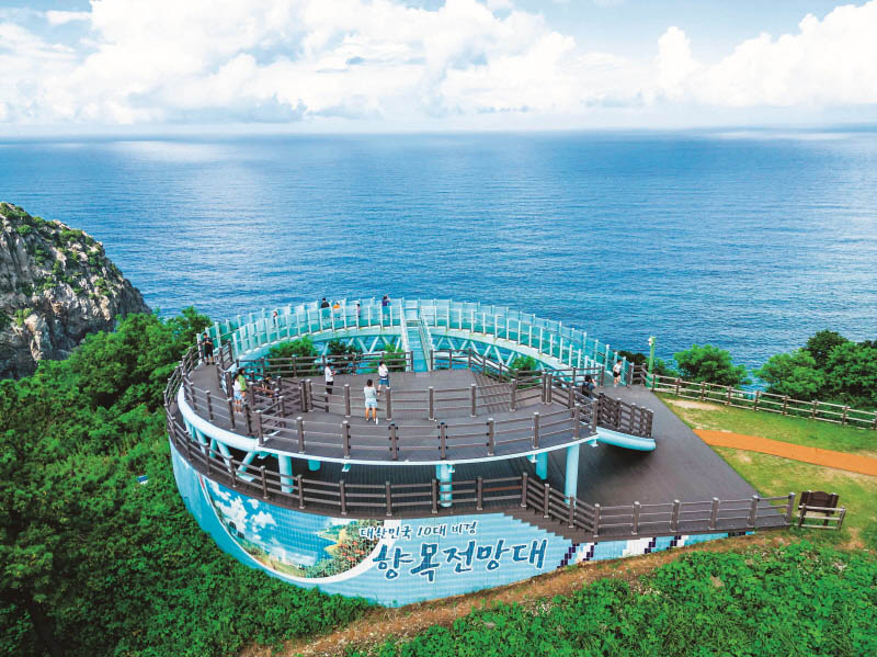
Hyangmok Observatory stands on Daepunggam, rising 150 meters high, with sweeping views of the sea. The western face of the cliff has been ranked by Korean media as one of the country’s top ten scenic spots.
© Korea Tourism Organization
Researchers at the Seoul National University Museum initially offered an alternate view, suggesting the island’s history began before that time. Now, they caution that an accurate timeframe is difficult to ascertain as no artifacts have been unearthed in subsequent surveys, and more precise investigations need to be conducted. Nevertheless, if the accounts in the History of the Three Kingdoms are true, it is highly likely that vestiges of Ulleungdo’s indigenous people from before the 6th century still exist somewhere on the island.
According to the History of Goryeo (Goryeosa), compiled in the 15th century, Usan faded into history when it was decimated by the Jurchen invasion during the reign of King Hyeonjong (r. 1009–1031). But the island was not entirely uninhabited — officials of the Goryeo Dynasty (918–1392) were frequently dispatched there. An entry dated November 8, 1018, notes that when the islanders were no longer able to farm due to Jurchen incursions, the government supplied farming tools. But in the mid-Goryeo period, the court discussed relocating the residents to the mainland, and based on records of actual relocation attempts, it is presumed that Ulleungdo was vacated and left desolate after the fall of Usan.
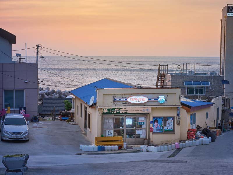
In days of yore, Cheonbu Port was used for transporting timber. Now it hosts an annual squid festival every August.
RESETTLEMENT
During the Joseon Dynasty (1392–1910), a policy was enacted under King Taejong (r. 1400–1418) to relocate Ulleungdo residents to the mainland due to frequent Japanese raids. Every two to three years, local military commanders were dispatched to survey and inspect the island. The rough waters of the East Sea made the journey perilous. In 1613, Kim Yeon-seong, commander of the Samcheok region, led 180 men to the island, but all were drowned when their ship capsized in a storm. In 1694, a government official named Yi Jun-myeong was assigned to patrol the island, but records state that he refused for fear of crossing the sea; in 1760, another official asked to be dismissed for similar reasons.
The Haengnam Coastal Walking Path links Dodong Port to Chotdaebawi Rock at Jeodong Port. Dotted with caves and rugged cliffs formed by coastal erosion, this geological attraction was named one of Korea’s must-visit destinations by CNN.
Then, in 1882, King Gojong (r. 1863–1907) decided that Ulleungdo should no longer be abandoned and sent Yi Gyu-won, a high-ranking military officer, to conduct an inspection and submit a report. Yi spent ten days inspecting the entire island and coast, and submitted a summary of his findings along with a map.
Titled Journal of Inspection of Ulleungdo (Ulleungdo geomchal ilgi), the report records a two-month journey, during which Yi departed from North Gyeongsang Province, surveyed the island, and returned to Seoul. It details the island’s daily weather, geographical features, and vegetation, the people he met, and his personal impressions. As a result, King Gojong issued the “Ulleungdo Resettlement Edict” in December 1882. The next year, 16 households totaling 54 people were relocated to Ulleungdo, beginning a new chapter in its history.
During his sojourn on the island, Yi met 129 people. Among them, 103 were from Jeolla Province. They had come from various areas, including the island of Geomundo, to build boats or harvest seafood such as seaweed and abalone. They turned to Ulleungdo out of necessity, to make a living. Wood was needed to build houses and boats, but logging was prohibited in Jeolla Province and large trees could not grow on Geomundo. In contrast, Ulleungdo had lush forests and abundant marine resources, so for generations, Jeolla residents shuttled between the mainland and the island.
For the fishermen of Geomundo, the island was a symbol of hope. This is epitomized in the lyrics of “Sulbisori,” a boating song they used to sing while twisting ropes: “I’m going, going, going / I’m going to Ulleungdo / […] I arrived at Ulleungdo / I see fine trees, Tamjin seaweed / In every corner of the island.”
The people who relocated to the island under the government’s resettlement plan adapted to its natural environment and developed a distinctive way of life. They subsisted on corn and potatoes, and supplemented their diet with mountain herbs, giving rise to a unique culinary culture featuring dishes not found on the mainland. In around 1910, the islanders began catching squid, for which Ulleungdo is now famous. Along with squid fishing, the island’s shipbuilding industry also developed.
Born of ancient volcanic forces, Ulleungdo is a natural wonder with a unique cultural heritage, offering not just spectacular landscapes but a journey into its storied past.

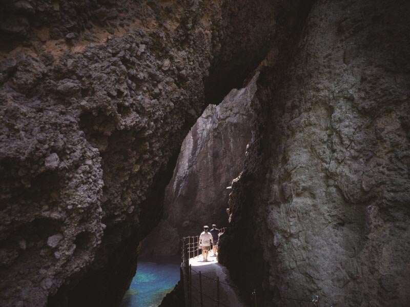
Gongam is an elephant-shaped rock in the sea, about 1.5 kilometers north of the beach in front of Chusan Hydroelectric Power Plant. Small boats can pass through its ten-meter-high tunnel, which is a popular spot for skin scuba divers.